Filter
Exclude
Time range
-
Near
NWSPhoenix
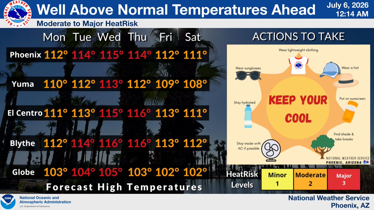
Temperatures will be well above normal this week, peaking during the Wed-Thu timeframe at 6°-9° above normal. Temperatures will then cool a few degrees heading into the weekend. This will result in Moderate to Major HeatRisk. Remember to practice smart heat safety. #azwx #cawx
1
1
539
NWSSacramento
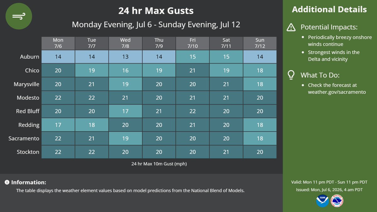
Cool to seasonable temperatures continue alongside periodically breezy onshore winds through early this week. Warmer temperatures and little lighter onshore winds are expected mid to late this week. #CAwx
2
4
575
vicmaluy
مساج منزلي فندقي في جدة الرياض الان بجدة بالرياض منزل فندق اطلب الان عن طريق البايو . . caWX
2
big_clutch1
Comparison of SST anomalies in the Niño 3.4 and Niño 1 2 regions, tracking observed 2026 data alongside historical analogs (ERSSTv6) and July ECMWF projections. Unprecedented projected basin-wide warming in Niño 3.4 and explosive coastal amplification in Niño 1 2. #CAwx #elnino
10
jchastainwx
Extensive cloud cover and a parent low did wonders Sunday to keep us away from the 90s. Abundant sunshine returns Monday to bring us back before building high pressure further brings the triple digits into play. #nvwx #cawx
39
NWSWPC
National High/Low temps for Sunday July 05, 2026: 113 at 4 miles northwest of Topock, AZ, Ocotillo Wells, CA, 4 miles east of North Shore, CA; 20 at Peter Sinks, UT #azwx #cawx #cawx #utwx
4
10
6,055
NWSBayArea
A Beach Hazards Statement is in effect Tuesday morning until Friday afternoon for Pacific Coast beaches. Remember: stay off of jetties, piers, rocks, and other waterside infrastructure, remain out of the water to avoid hazardous surf, and never turn your back on the ocean! #CAwx
6
9
3,684
SF_WeatherAlert
NWS Alert> Beach Hazards Statement in effect from early Tuesday in Pacific Coast Beaches #cawx
53
rosamond_cawx
2ND WARMEST FIRST HALF OF YEAR IN HISTORY! The avg temp for Jan to Jun 2026 was 61.9. This is the second warmest start to a year in history and is 2.9 degrees above normal. #CAwx #socal #wx
104
jchastainwx
Dry air combined with the light nature of the showers that have swung through mean we got pretty much nothing of significance Sunday. Stray storms along the California-Nevada border further north have produced some locally higher totals close to 1/2" as of 7pm. #nvwx #cawx
1
79
RobMayeda
7/5/2026: If you ever wonder why some Summer warm-ups are more humid than others, here is one reason why. It also happens to be part of a pattern we could be seeing later this week and into the next. Stay tuned. #CAwx
1
5
28
2,242
Mizuho Sonny Muramoto retweeted
NWSPhoenix
Low temperatures this morning were mostly in the 80s across the lower deserts. #azwx #cawx
3
19
2,947
NWSLosAngeles
Temperatures across the area look to warm this week with daytime temperatures expected to climb up into the 90s to 100° across the area. Places near the coast will stay cooler but are still expected to see warm temperatures in the coming days. #socal #cawx
2
27
90
13,679
NWSPhoenix
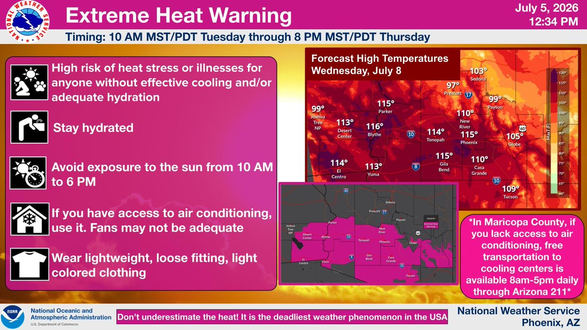
The Extreme Heat Watch has been upgraded to a Warning for Tue - Thu. High temperatures will reach up to 112-116°F with morning lows in the 80s to 90°F in Phoenix. Areas of major HeatRisk is likely across the lower deserts and even some higher terrain. Stay cool! #azwx #cawx
12
30
3,295
NWSSanDiego
It's summer, it's hot - but temps this week will be 4-10F above normal, putting vulnerable populations at risk (kids, elderly, pets, outdoor workers). Are you prepared for the heat? If spending time outdoors, ensure you have plenty of water & take breaks in the shade or AC! #cawx
6
20
63
7,419
NWSBayArea
Low clouds have retreated to the coast once again as of early this afternoon. Meanwhile, high-level clouds have exited the region earlier than originally anticipated, opening the way for clearer skies inland! 🌤️🌊 #CAwx #BayAreaWX

ALT A regional satellite image loop titled G18-ABI-CONUS-geo-color.GIF, dated July 5, 2026. The imagery shows Northern and Central California under midday sun. A thick, textured deck of low marine stratus clouds covers the Pacific Ocean and is pushed tightly against the immediate coastline, including the mouth of the San Francisco Bay and Monterey Bay. Further inland, the widespread layer of high, wispy clouds from earlier in the day has pushed entirely eastward over the Sierra Nevada mountains and Nevada border, leaving the San Francisco Bay Area entirely clear and sunny. Highway overlays and city markers are sharply visible through the clear inland air.

2
5
32
6,161
SWA_Fresno
NWS Alert> Updated: Lake Wind Advisory is in effect in West Side Coastal Mountains north of 198 and San Luis Reservoir until Monday evening #cawx
68